
Community feedback will be reviewed and summarised, with key outcomes reported back to the community.
Alstonville to West Ballina Shared Path Project
Share Alstonville to West Ballina Shared Path Project on Facebook
Share Alstonville to West Ballina Shared Path Project on X (formerly Twitter)
Share Alstonville to West Ballina Shared Path Project on Linkedin
Email Alstonville to West Ballina Shared Path Project link
Consultation has concluded
The Ballina Shire Bike Plan aims to make Ballina Shire bicycle-friendly and better integrate cycling in our transport network. In recent years, staged funding and construction have extended the coastal shared pathway, improving connections between Ballina and Lennox Head.
However, a feasible route for a shared pedestrian and bicycle path between Ballina and Alstonville has not yet been identified, meaning progress on this important connection has not been possible to date.
With funding from the NSW Government’s Get NSW Active program, Council has investigated potential route options for a 3-metre wide shared path linking the two towns. Four potential route options were identified following consideration of a number of locations and of their environmental, engineering, cost and heritage constraints.
These identified options included two alignments south of the Bruxner Highway and two northern alignments, along with a connection to the Duck Creek Mountain Bike Park (required if a route on the southern side of the Highway is selected).
Concept designs and high-level cost estimates have been prepared for the four identified route options and the Duck Creek Mountain Bike Park connection.
This work will help Council finalise the preferred route location and support future planning, funding applications, detailed design and staged construction.
Council is now inviting the community to review the concept designs and share feedback on the route options to help inform the finalisation of a preferred pathway alignment.
Project study area
For this project, the start and end points for the proposed shared path were identified as:
- Alstonville – the existing shared path at the intersection of Main Street and Daley Street, which already connects to Alstonville’s pathway network.
- West Ballina – the western end of the existing shared path on the southern side of River Street, near the eastern boundary of Ballina Waterfront Village (about 200 metres east of Emigrant Creek Lane).
These locations link with existing and planned pathway connections to Ballina, Alstonville and Wollongbar.
Concept designs and route options on public exhibition
The route options selection process has identified four potential route options for the shared path between Alstonville and West Ballina, along with a connection to the Duck Creek Mountain Bike Park if a southern route is selected.
A range of supporting documents are available to view or download, including route options analysis reports, concept design report with cost estimates, concept design drawings, plans of the proposed routes and detailed sections. Maps for the southern options (Options A and B) also show the location of the proposed Mountain Bike Park connection.
Council invites the community to review the information and share feedback via the survey at the bottom of this page.
The complete reports include:
- Alstonville to West Ballina Shared Pathway – Options Analysis Report (February 2025)
A 42-page report that investigates, analyses and ranks potential route options. It includes a high-level assessment of key constraints and considerations such as waterways and flood inundation, vegetation and threatened species, land use and tenure, soils and landscape, Aboriginal heritage, user experience and indicative construction costs. - Alstonville to West Ballina Shared Pathway – Concept Design Report (December 2025)
A 44-page report providing an overview of the project, concept design development, assessment of the final route options, cost estimates, and recommendations to inform the next stage of the project. - Alstonville to Ballina Shared Path – Concept Design Drawings (Full Plan Set)
A comprehensive set of 140 drawings illustrating the proposed pathway options, including typical cross sections, plan views, longitudinal sections, road crossing layouts, bridge concepts, facility area plans and the Mountain Bike Park connection. Along with examples of supporting infrastructure, facility area plans and example facility infrastructure plan.
For convenience, separate plan sets for each of the four identified route options are also available to view:
Option A: Preferred Southern Route Plans
The preferred southern route follows Wardell Road, then generally runs south of the current Bruxner Highway, partly along the old abandoned highway formation. It includes a connection to Duck Creek Mountain Bike Park (via an underpass of the Bruxner Highway), and crosses Emigrant Creek via a proposed new footbridge before joining Smith Drive. This alignment provides a reasonably direct and scenic path that utilises existing infrastructure and represents the most practical and cost-effective option.Option B: Alternative Southern Route Plans
The alternative southern route generally follows a similar path except at Alstonville where it follows Ballina Road rather than Wardell Road. While this provides a more direct and accessible route, it requires a very costly footbridge over the Bruxner Highway, significantly increasing overall costs.Option C: Preferred Northern Route Plans
The preferred northern route follows Ballina Road in Alstonville before continuing along the north side of the Bruxner Highway. It offers an accessible direct route, but requires long lengths of elevated boardwalk in the ‘Ballina Cutting’ section, making it more complex and costly to build and maintain. These boardwalks would be confined by side safety barriers, include steep grades, and present potential safety risks, such as downhill speeding or loss of control involving bicycles, e-bikes, scooters and other similar devices.Option D: Alternative Northern Route Plans
The alternative northern route uses existing paths in Alstonville via Green Street to Teven Road at the western end before rejoining the Bruxner Highway. It has similar challenges to the preferred northern route.
Cost Estimate Summary
| Option | Route details | Concept Level Estimate Ex GST |
| A | Preferred Southern Route including Duck Creek Mountain Bike Park connection | $27,300,000 |
| B | Alternative Southern Route including Duck Creek Mountain Bike Park connection | $31,500,000 |
| C | Preferred Northern Route | $34,100,000 |
| D | Alternative Northern Route | $34,800,000 |
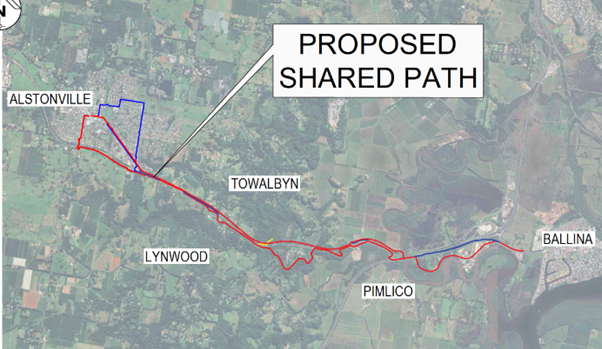
Image: Proposed Southern (red) and Northern (blue) routes and Duck Creek Mountain Bike Park connection (yellow). Detailed designs are provided in the resources attached.
Next Steps:
Following public exhibition and receipt of submissions a report will be provided to Council regarding the route selection and concept design.
If Council finalises a preferred route and resolves to proceed, the next steps are expected to include:
- Identifying priority sections for staged construction
- Undertaking required planning approvals and environmental assessments
- Applying for grant funding to support detailed design and construction
- Preparing detailed designs and refined cost estimates
- Delivering construction of priority stages (likely by contract)
Documents on exhibition
-
 Alstonville to West Ballina Shared Path - Route Options Analysis Report - Burchills 27 February 2025.PDF (3.58 MB) (PDF)
-
Alstonville to West Ballina Shared Path concept design report (including cost estimates) (38.3 MB) (PDF)
-
Alstonville to Ballina Shared Path Concept Design Drawings (Part A) (144 MB) (pdf)
-
Alstonville to Ballina Shared Path Concept Design Drawings (Part B) (118 MB) (pdf)
-
Alstonville to Ballina Shared Path Concept Design Drawings (Part C) (47.5 MB) (pdf)
-
Option A - Alstonville to West Ballina Shared Path - Preferred Southern Route Plan (109 MB) (PDF)
-
Option B - Alstonville to West Ballina Shared Path - Alternative Southern Route Plan (42.6 MB) (PDF)
-
Option C - Alstonville to West Ballina Shared Path - Preferred Northern Route Plan (67.5 MB) (PDF)
-
Option D - Alstonville to West Ballina Shared Path - Alternative Northern Route Plan (16 MB) (PDF)
Who's Listening
-

Phone 1300 864 444 Email patrick.knight@ballina.nsw.gov.au